May 29, 2015

Surprising Sonyea State Forest


Normally for Memorial Day I go on a crazy 1,000 mile road trip but I’ve now run out of National Park sites in that radius and there was too many things to do in town so I decided to stay home. However, I had to do something to assuage my road trip guilt so I decided to head down to the Sonyea State Forest, solely based on looking at a map and determining it was fairly close and I had never been there before. I had always driven past the Sonyea exit on the highway but this time I exited and found my way down a gnarly dirt road. The forest is DEC land which means its just preserved, there’s no development of anything.  
As I was traveling down the dirt road I was getting nervous because some of the potholes were pretty massive but I navigated around and eventually came to a stop sign leading into the woods. The road kept going buy my nerves were shot so I decided that was as good a place as any to disembark. The trail follows along the top of a ridge in the forest and then goes steeply downhill where you then hike at the bottom of the ridge along Keshequa Creek.
 
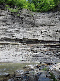
After hiking through the woods I saw a trail cutting off towards the creek and as I emerged I saw a towering cliff now stood above the little creek and it was so unexpected that I stopped in my tracks. I had no idea the beauty this little state forest was holding. After exploring a bit I went back to the main trail and took a couple more spurs off to the creek where there was waterfalls, swimming holes and more rocks and cliffs. The geology of the area was really fascinating and not at all what I had envisioned. I had my foster dog Rita with me so we only went about 3.5 miles round trip but I would definitely go back again to explore more of stunning Sonyea State Forest.


May 28, 2015

Pinnacles National Park

My last stop in California was Pinnacles National Park. After grabbing a monster breakfast burrito in San Luis Obispo, I headed up into our newest National Park (having been upgraded from a National Monument in 2013). I saw little traffic on the way in but when I got there the parking lots were pretty packed and there was a guy directing traffic so I guess it’s a popular destination on the weekends. Apparently its unbearable to visit in the summer because of the heat so spring and fall are busy seasons.  
After a quick stop at the visitor center to pay the entrance fee I drove up and parked at the Bear Gulch Day Use area  and headed up the Condor Gulch trail. It was only 1.7 miles one way but the elevation gain is over 1,000 feet. The trail is full of switchbacks and has little shade so I was pretty pissy by the time I got to the top because I wasn’t finding anything too great about the park. 
Condor Gulch Trail
However, as I merged onto the High Peaks Loop and the vista opened up before me I got my second wind. The park is so named because pinnacles are what remains of an extinct volcano that migrated along the San Andreas Fault.
I continued along the High Peaks trail to Scout Peak. The trail goes through a steep and narrow section where you have to climb up (and down) rocks that have footholds that look like dinosaur footprints.
Dino footprints
Steep trail
 Scout Peak has a restroom which was a nice surprise so I took a quick break before heading down the Juniper Canyon trail. What’s interesting about the park is that there are two entrances and it takes more than an hour to drive between the two but the trails connect them so its easy to see both sides of the park no matter which entrance you use. The east is the main entrance through with all the services. I joined up with the Tunnel Trail and took it back up the mountain to rejoin the High Peaks trail. 
Tunnel
Since I had a red eye flight, I had all day to kill so I figured I would try to do as many trails as possible. I descended down the High Peaks trail again and continued all the way down to the Rim trail which leads to the Bear Gulch Reservoir. Although the vistas were great, it was nice to head down into the trees and see some water.
Bear Gulch Reservoir
I took a break beside the reservoir before finishing my hike down through the Bear Gulch Caves and Moses Spring trail. The caves are actually talus caves which are formed by the openings among large boulders that have fallen down into a random heap so they’re somewhat airy. There are parts where you need a flashlight but I stuck to the easy trail.
Talus caves
I was exhausted by the time I got back to my car. I had hiked nearly 8 miles. It was nice through because I had all day so I could meander at my own pace and stop and soak up the scenery. Despite all the cars in the parking lot, the trails still allowed a fair amount of solitude. I stopped in the Peaks View parking lot on the way out to reorganize my car and suitcase and get ready to head back. Upon arriving in San Jose I stopped at In N Out burger for one last f ix before heading into the airport. My flight was at 10:30 and I got to the airport around 8 and it was completely deserted. I was literally the only person in the security area. It was pretty funny. My flight back was pretty miserable, only because I cant sleep on planes so I was a zombie during my ATL layover. I finally arrived home mid morning Sunday to the steam heat of Rochester. It was crazy that the entire week I was gone it was in the 80’s and 90’s here so it was a shock to my system after the coolness of California.
I had such a spectacular trip and it was great to be away for so long. My Airbnb experience was amazing and I loved having my own place to go back to all week. I completed 13 more National Park sites which I felt great about and am excited for the next adventure (wherever that may be!)


May 26, 2015

California Route 1: Big Sur Coast Highway


Route 1
On Friday I headed out of San Francisco and down Route 1 following the Big Sur Coast Highway and the San Luis Obispo North Coast Byway. It’s a 123 mile road that twists along the coast. Along with my quest to see all the NPS sites, I have a parallel quest to see all the All-American Roads (of which there are about 30). I’d always envisioned driving the California coast in a convertible but the wildly variable weather and the omnipresent fogs killed that dream of ever happening. I had to settle for a Kia Rio. My first stop was Carmel-by-the-Sea where I could glimpse the famous Pebble Beach. I’m not a golf fan so it wasn’t that impressive to me. 

Pebble Beach
The best part of Carmel is Point Lobos. It costs $10 to enter but is worth every penny. You can park along the road and walk in but I was planning on hiking 5 miles so I didn’t want to add more hiking onto that. I parked in Whaler’s Cove and hiked a huge loop from the North Shore trail to the Cypress Grove trail, to Sea Lion Point trail and then along the South Shore trail until I cut back across to the parking lot via the Mound Meadow trail. 

Sea lions
It was breathtaking. The trail hugged the coast so there was constantly changing views. I couldn’t get over how blue the water was. It was by far the highlight of the day. 


I reluctantly climbed back in my car and drove through Garrapata State Park. It’s on either side of the highway so its mostly just viewpoints. By this point the clouds had descended but the bright flowers made up for the gray skies.
Garrapata State Park

I drove down to the famous Bixby Bridge; one of the tallest single-span concrete bridges in the world. It's also where a lot of the iconic Big Sur pictures are taken so it was kind of an out of body experience to actually be seeing it in person. 
Bixby Bridge
My friend Melissa had done Point Lobos and Bixby a few months ago and I was so jealous of her pictures that knew that I had to find a way to incorporate them into my visit and it was so worth it.
Pfeiffer Falls
My next stop was inland at Pfeiffer Big Sur State Park. I hiked the Pfeiffer Fall and Valley View Trail. The falls are pretty small and the valley view wasn’t that great but the hike through the redwoods to get to both of those spots was what made the trail.   

Valley View
Hiking through redwoods
My next stop was Julia Pfeiffer Burns State Park which is famous for McWay Falls which pour 100 feet into a picturesque cove. Through signage at the overlook I learned that a landslide in the mid 80’s caused the topography to alter and the falls now only spill into the ocean when the tide is in. It was another stunning vista.

McWay Falls

 After that, I focused on just driving the road and only stopping occasionally at some pull offs. I was amazed to get up close to elephant seals at Piedras Blancas Point. Everywhere else I had seen seals this week had been at a respectable distance but this boardwalk literally is a few feet above a beach where there’s hundreds of them. There is signage along the way telling about them so it was interesting to learn.

Elephant seals

I was hoping to see one of the big males with the huge nose but it was the wrong time of year for that. I finally arrived in San Luis Obispo where I was bunking down for the night.
Driving into San Luis Obispo