Last night the lady in the site next to me had come over and asked if I had a smartphone. I said yes and she said a weather alert had popped up on hers and she wanted to make sure I got it since I was in a tent. I hadn’t so I was grateful she was looking out for me. I didn’t have a hammer and I had just pushed my tent stakes partway in so I grabbed a tire iron and used that to pound them in a bit more firmly. I also cleared out my car in case I had to move in there. Well when I got up at midnight to use the restroom it was lightning like crazy off in the distance and the wind had started to pick up. I ducked into my car and tried to sleep but it was super uncomfortable. I could stretch out since I’d put the seats down but it was so hard. I got up at 5am and saw this.
 |
| Wind Blown Tent |
Only my cot and Rubbermaid tote had prevented my tent from blowing away since it was blown off the stakes. Thank goodness it hadn’t rained since my rain fly had also blown off. I packed up and headed east again to go to Bismarck. I’d wanted to check out the capital.
 |
| Bismarck |
It’s known as the Skyscraper on the Plains and it’s Art Deco style so it’s pretty ugly. I headed North to Knife River Indian Villages.
 |
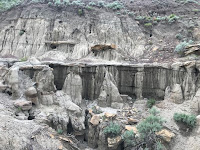
| Knife River Earthlodge |
 |
| Knife River |
It has a reconstructed earth lodge that you can explore which I enjoyed. I’d never really learned about earth lodge dwelling cultures so it was neat to see. I hiked down to the Knife River where you can see the indentations in the ground. When I had started down the trail I had passed a wooden drying rack but on the way back I saw it on the ground and the lawn mower parked next to it so I think the kid who was mowing the lawn knocked it over. Oops. I looped back east and drove past the North Unit again on my way to Fort Union.
 |
| Fort Union |
It’s a unique unit because the parking lot is in Montana and is on Mountain time but the Fort itself (1/8 mile away) is in North Dakota and on Central time. It’s a reconstructed fort so there’s not a lot of rooms to explore but the visitor center is nice. Down the road is Fort Buford which is a state historic site but I figured I’d check it out.
 |
| Fort Buford |
I got a tour by a very passionate guide who shared some really interesting tidbits of history. There is also a Missouri Yellowstone Confluence Interpretive Center that has even more exhibits about the area. A lot of this region is devoted to Lewis and Clark which I’ve never really delved into so it was fun to learn. I had originally thought of camping at Fort Buford since they had a small primitive campground but it’s next to a cemetery and there was no one else there so I decided to keep heading west. I went to Makoshika State Park in Glendive.
 |
| Makoshika Sunset |
A lady I hiked with last weekend told me about it. It’s the largest state park in Montana. The campground (only 15 sites) was full so I continued on up the hill to their dispersed camping sites. The first one I stopped at was empty and it was perfect. It had a vault toilet, picnic table and fire ring so I set up camp. I quickly realized that around the corner and behind the trees was another site and it had a family with four-wheelers that were riding around. It was pretty annoying. As the sun was setting they put those away and turned on a radio. I decided to go find a quiet spot to watch the sunset. Across the street was 2 more campsites but the driveway was locked so there was no one there. I walked in and settled down to watch a gorgeous sunset.
 |
Makoshika Sunset
|
I slept well but woke to cloudy skies. I packed up and decided to do a couple short hikes and leave before it started raining. I drove around but their roads are all gravel and not in the best shape so I drove back to the trail down the road from my campsite and hiked the Caprock Trail.
 |
| Caprock Trail |
It went down into the badlands and out to a natural bridge.
 |
| Natural Bridge |
It was cool to hike among the badlands but the trail was awful. It was really eroded and require scrambling in some places because it was so steep. I hiked another overlook trail but it literally went under a power line.
 |
| Doc Hiatt Overlook |
I think the park is the highest elevation in Glendive so its summits all have communications towers and power lines. It kinda ruins the vista. I hiked the Bluebird trail by the visitor center but it was more of a mosquito trail.
 |
| View from Bluebird Trail |
I did flush out 2 pheasants though. I had seen 2 more pheasants when I was driving through Montana yesterday. They are pretty rare back east so it was neat to see. The last trail I did was the Hadrosaur trail. It goes up to a hadrosaur fossil.
 |
| Hadrosaur Trail |
Again, the trail was pretty shitty. It starts by crossing a muddy creek (with no bridge). Several of the wooden erosion control steps are loose so when I stepped on them they wobbled. The ones that had been removed still had rebar in the ground so I tripped over that. Maybe I’m snobby because I really only go to National Parks but man this state park really needed a lot of maintenance.
 |
| Crappy trail |
I started heading back West and sure enough the rains moved in. I had pulled over twice because the rains were so heavy I could barely see. One of my stops was at Pompey's Pillar. It was where William Clark had carved his name into this massive rock. It was raining so hard that I didn’t hike out to the pillar but the visitor center was really informative. By the time I got to Billings, I was crawling along the interstate at 40mph. I ducked into Best Buy to drop off my camera and the roof was leaking. I went into Goodwill to shop and the emergency lights were on because the power had gone out. It was like a hurricane. Goodwill had some great stuff so I emerged 2 hours later and the rains had stopped. I did some errands at WalMart and headed back to Yellowstone. It was about 1500 miles but I got to see a new state, a new National Park, badlands, and learn about some really fascinating historical figures.
 |
| Makoshika |


No comments:
Post a Comment