July 31, 2012

Driving Home

 A large section of the Trans Canada Highway passes through Lake Superior Provincial Park and it was my favorite part of the trip, especially Old Woman Bay. The name for the bay and river come from a rock formation near the river's mouth that resembles the face of an old woman (I didn’t get it).
Next up came the heart pounding adventure of the trip at the Agawa Rocks Pictographs. 
This was one of the few short trails in the Park so I figured I would check it out but I had no idea what it consisted of. The trail to the site of the Pictographs is short, but very rocky and rugged and you have to walk out on a ledge to view the Pictographs.  The pictographs can only be accessed when the lake is calm and there are numerous warning signs that people have been injured and died here. 
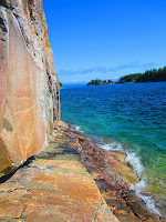
This is a sacred site where generations of Ojibwe came to record their dreams and spirits in red ochre. The lake was fairly calm so I decided to scurry out. The pictographs were pretty cool but I found it hard to concentrate with Lake Superior lapping at my feet.
This is the trail!
My adventure across the Trans Canada highway ended when I jumped back across the border in Sault Ste Marie. I was having a good time waiting on the bridge and checking out the locks and the freighters but quickly grew frustrated by the long wait at the border. Then I got selected for a random search and had to pull over but it actually went pretty quick. I grabbed a quick bite to eat and made it to my hotel at 9pm.
Soo Locks
I had just planned on a long, monotonous drive across Canada on Saturday and had no idea the scenic wonders that awaited on the Trans Canada highway! It was a long day but probably my favorite of the trip. If you ever have a chance to drive the highway, it is a must see.
Despite the copious warnings, no moose were seen
The next morning I was up and on the road at 6:00am as I had to make it home. My first stop was in St. Ignace, MI. 2 years ago I ferried out to Mackinac Island and it was amazing. I didn’t have time to make it out to the island so I instead stopped at Straits State Park in St. Ignace, MI. It was so beautiful and I couldn’t resist seeing the Mackinac Bridge from all different angles. 
 
Opened in 1957, the bridge is the third longest in total suspension in the world and the longest suspension bridge between anchorages in the Western hemisphere. 
A memorial to those who lost their lives building the bridge
 When I first crossed the Bridge 2 years ago, a Good Samaritan in front of me paid my toll so I did the same when I came back. I planned on doing so again this year but since I was there at 7am on a Sunday there wasn't much traffic. I crept along, looking in my rearview mirror for a car behind me but they kept going to the open stalls. Finally, one pulled behind me and I told the toll collector that I would like to pay for them. Now it's officially a tradition!
 
 I also checked out the Father Marquette National Memorial in the park. 
 
Jacques Marquette was a French priest and explorer and he founded a Jesuit mission in 1671 in St. Ignace and was buried there in 1678. He lived among the Great Lakes and mastered several native languages and joined Louis Jolliet in his expedition to explore and map a navigable route to the Pacific Ocean, which resulted in the French discovery of the Mississippi River. After that, I cruised straight home, only stopping for lunch and to cross into Canada and back. Maybe it was because of my random inspection the day before but I had never gotten across the border quicker. I had such an amazing trip and am so grateful that our company gave us this week of. I definitely made the most of it!

July 29, 2012

Grand Portage State Park and Trans Canada Highway


 Saturday morning dawned nice and sunny so I decided to hike the Mount Rose Trail at the Grand Portage. It’s only one mile round trip, and you can take a self guided brochure that highlights geology and vegetation along the way.  
The trail gave a nice overlook of the National Monument and also gave a glimpse of the Grand Portage trail.
The Grand Portage gap
 I stopped at a few overlooks on my way up to Grand Portage State Park. The Park is home to High Falls, the highest waterfalls in Minnesota. 
 
They were pretty cool to check out but this is the best thing I saw at the Park:
Can you believe the size of this guy!? He was right behind the visitor center and it took me a second to realize he was real and not some display. I was very impressed. Right next to the State Park is the border crossing into Canada so I hopped on the Trans Canada highway and drove east the rest of the day.
It was stunning! I was just expecting a long day of driving but this road is truly a scenic wonder.

Outside of Thunder Bay I traveled on the Terry Fox Courage Highway and stopped at a scenic overlook that told the story of Terry Fox. I had never heard of him before but his story is amazing. In 1980, with one leg having been amputated, he embarked on a cross-Canada run to raise money and awareness for cancer research. He made it 143 days and 3,339 miles before the spread of his cancer eventually forced him to end his quest. He ran the equivalent of a full marathon every day!
I stopped at the Aguasabon River Gorge in Terrace Bay. The river is 43 mi in length, and plunges down 98 ft at the Aguasabon Falls.
The lighthouse in Terrace Bay was odd because it was located in a shopping plaza but you can climb it for a view ofLake Superior. It’s a 50 foot replica of the Lighthouse at a nearby island which is the tallest lighthouse on the Great Lakes at 224 feet above sea level.
While driving along, I started seeing signs for “The home of Winnie the Pooh” and pulled over in White River to find out the story behind that. 
 
I learned that in August 1914, a trapped black bear cub was sold to a soldier in White River, who named it after his hometown, Winnipeg. He was on his way to England to fight in the first World War and had to turn the cub over to the London Zoo when he was called off to France. The London Zoo is where AA Milne came across him and the rest if history.
I’m a sucker for waterfalls so I pulled off at a sign for the scenic high falls in Wawa. It’s down a dirt road and there are fields on either side filled with no trespassing warnings. The falls are only 75 feet but it was a nice spot to get out and stretch. They are surrounded by a fence because of a nearby dam and power station and there are warning signs not to get near the falls because of the rapidly changing waters.
Despite the fact that this was a gorgeous summer Saturday I noticed that there was very little traffic on the road and that everywhere I went I was either the only one there or one of only a few people. I loved it but it was odd because usually scenic highways attract people but I guess not.

July 26, 2012

Grand Portage National Monument

  Despite being soggy from Isle Royale, I headed over to Grand Portage National Monument which is right down the road from the docks. I wasn’t expecting much (I hadn’t really researched it) but it was one of the coolest NPS sites I’d been to!
http://upload.wikimedia.org/wikipedia/commons/e/ec/Voyageur_canoe.jpg 
The Grand Portage is an 8.5-mile footpath which bypasses a set of waterfalls and rapids on the last 20 miles of the Pigeon River before it flows into Lake Superior. Voyageurs would traverse this route as it had provided access between the furs in the wilderness and the companies that would purchase those furs. Voyageurs were the people who transported furs by canoe during the fur trade era and boy did they have a hard life! 
http://www.nps.gov/grpo/planyourvisit/images/HC_exhibits.jpg
Hernias were a common malady
Voyageurs were expected to work 14 hours per day and paddle at a rate of 55 strokes per minute. When portaging they were responsible for carrying 2 bundles that weighed 90 pounds each! It was tough, dangerous work and they weren’t treated very well at all by their employees. Karl (an interpreter) gave a great talk on the misconceptions of Voyageurs and I learned a lot.

 You can visit the Historic Depot where there is a great hall, kitchen and canoe warehouse. 
 
The Great Hall was spectacular! The kitchen had been cooking that day so it was nice and toasty and a good place to waem up. There's several rooms you can check out as well, including this room filled with furs.
 
There’s also an Ojibwe village, a dock and some historic gardens. There were interpreters there as well that really brought the place to life. Despite the cold rain, it was a great way to pass the rest of the day.
Birchbark canoe
There is also a Heritage Center with exhibits, artifacts and films. I was fascinated by the Voyageurs and am so glad I got to check out this gem. At this point I was tired, hungry, cold and wet so I went back to the campground and showered and headed up to the convenience store where they had a little grill and got myself some broasted chicken. It had a unique flavor that I don’t know that I’d choose again but the rest of the sides were awesome. The sun finally began peeking back out so I took a walk along the water’s edge to get some gorgeous sunset photos.


July 25, 2012

Isle Royale National Park

Friday morning I headed a few miles down the road from my campsite to the docks for my trip out to Isle Royale. You can get to Isle Royale from 2 different points in MI but Grand Portage, MN offers the shortest distance for a manageable day trip. Isle Royale is the largest island in Lake Superior and is entirely a national park. There are a few scenic stops on the way out to Isle Royale
  • The Little Spirit Cedar Tree: Over 400 years old, the ancient cedar tree was believed by the Chippewa to have the power to protect and calm the waters of Lake Superior during travels. It was customary for small gifts to be left for the tree as a protective measure before trips on the Lake. You can only see this tree by boat as public access was restricted due to vandalism.
http://www.isleroyaleboats.com/images/gallery/america.jpgThe Sunken Steam Ship "America": This 185 foot long steamship serviced Isle Royale and the North Shore until 1928 when she hit a submerged reef and went down. The bow of the ship is less than 2 feet from the surface but with the gray skies and waters, we couldn’t see it. Here's what it looks like on a clear day though.

We arrived at the Windigo docks and were first instructed in how to behave on the island so we could best preserve it. 
Playing with moose antlers is acceptable
The first thing I did was join up with a ranger walk. Our ranger, Karen, was absolutely wonderful  and it was one of the best ranger programs I’ve done. I learned so much! For instance, did you know you can eat the leaves of a daisy plant? Isle Royale National Park is known for having wolves (who walked over the ice) and moose (who swam over). While I didn’t get to see any, I did learn about this unique closed environment. Isle Royale has been colonized by roughly just one third of the mainland mammal species, due to it being so remote. We did get to see this little guy cuddled up in an old cold storage room.
 
In addition, the environment is unique in that it is the only known place where wolves and moose coexist without the presence of bears. The nature trail has a unique “moose exclosure” that shows how different the island would look if moose weren’t there.  I had worked up quite an appetite after the ranger program hike so I grabbed a sandwich from the small store and ate under the eaves while it rained.
  
Luckily the rain let up so I was able to head out on my own to explore for an hour or so before the boat left and the sky cleared for about 15 minutes.
 
 Since Isle Royale is so dense with trees, I focused on taking pictures of the variety of plants and appreciating its unique ecosystem. 


Before boarding the boat I listened to another ranger talk on the history of people living on Isle Royale (Indians, fishermen, copper miners, tourists). We did get to see the Rock of Ages Lighthouse on the way back but then it started pouring so I cuddled up inside the boat until we got back. 
  
It was nice to be able to access such a remote park but I would love to go back and do some hiking and camping to really see more of the island.