July 21, 2014

Wheeling, WV and Oil City, PA

Wheeling, WV
The last day of my trip was primarily driving home but I made a few stops along the way. My first stop was to walk the riverfront in Wheeling, WV. There were some interpretive exhibits that told the story of how Wheeling came to be. I also drove through Oglebay Park which was huge and had all sorts of amenities like a gold course and ski hill. I drove to the visitor's center for the Rivers of Steel National Heritage Area in Homestead, PA but it wasn’t open so I drove over to the Rachel Carson homestead. It wasn’t open either but it had picnic tables so I heated up a can of soup and had lunch there.
Rachel Carson home
My last stop of the day was Oil Creek State Park. I hiked the Blood Farm Interpretive Trail which told the story of the farm that produced a lot of oil. The park is such a peaceful place that its hard to envision it as an oil boom town. The Petroleum Centre Walking Tour was fascinating to me. Numerous interpretive signs tell the story of a company town had no government, law enforcement, sanitation or public works. Apparently gold miners would come here after busting out West and be scared of how lawless this place was. I imagine it takes quite a lot to scare a 'forty niner'! I wasn’t too familiar with Pennsylvania’s oil history and found this park to be a great place to learn.

Blood Farm trail
I had a whirlwind of a trip but thanks to my impeccable planning and sense of timing I never felt overwhelmed. This is the first trip where I planned meals and bought a cooler so I ate like a queen everyday. I still have ~175 NPS sites left to see but I am down to only 8 states left. I am toying with setting the goal of reaching all 50 states by the age of 30 but with Hawaii and Alaska still on the list, I need to assess just how realistic that is. When did that ever stop me before ;)?

New River Gorge National River


Sandstone Falls

On July 4th I continued my journey through West Virginia and saw some of the most spectacular scenery of my trip along the New River Gorge National River. My first stop was Sandstone Falls where the river transforms from a peaceful river into a raging torrent  as it begins its descent though the gorge. I hiked along the boardwalk for a view of the falls before hopping in my car and driving to the other side of the river where I stopped at the Sandstone Falls overlook which is 600 feet above the river.
Sandstone Overlook
Continuing on, I went to the Grandview area which was my favorite of the day. A short walk from the car us the main overlook which was one of my favorite views of the whole trip. 
From the main overlook, I hiked along the Castle Rock trail that went under overhanging cliffs and back on the Rim trail which offers more beautiful views.

Castle Rock trail
The Tunnel trail was also in the area and is a short walk through large boulders that create cave like tunnels. I drove down to the Turkey Spur overlook for even more views. That overlook is a bit more strenuous to hike to because of several stairs but the stairs go over massive rocks that trap cool air in between them and act like a national air conditioner.

Thurmond
The Thurmond Depot was my next stop and it was like a place frozen in time. Thurmond was a boomtown in the early 1900s and a short walking tour took me past the old buildings and gave a sense of life in a railroad town. It was utterly fascinating but the coolest thing was that the depot is still an active Amtrak stop which boggles my mind because it is so remote.
Thurmond
My next stop was at one of the most photographed places in West Virginia: the New River Gorge bridge. It was completed in 1977 and is the longest steel span in the western hemisphere and the third highest in the United States. The Canyon Rim visitor center offers views of the bridge and exhibits on life before and after the bridge. 
To get a sense of just how much the bridge changed the community, I drove along Fayette Station Road which was the old route across the river. I took much longer than the anticipated 40 minutes as I stopped at all of the pulloffs along the way to read the interpretive signs. I could hardly imagine how people would complete that drive in the winter in the old days.
Fayette Station Bridge
Every spot I stopped at along the New River Gorge was amazing with fascinating history and beautiful views. It takes a while to drive between the spots because most are off major highways and down one lane roads but it is so worth it.
Summersville Lake
Near Summersville Lake, just north of the New River Gorge National River, is the Gauley River National Recreation Area. I stopped at Carnifex Ferry State Park which had some short hiking trails to overlooks of the rapids. From high up the rapids seem pretty innocuous but they are Class V and above rapids.
Leith Run Campground
My final stop of the day was at my campground on the Ohio River. I forgot that I had booked a walk in site so I drove around the campground loop twice looking for my site number. I finally found it and had to cart my gear on in. After I got settled and fed, I relaxed along the quiet river.

Cumberland Gap National Historical Park and Bluestone National Scenic River


Pinnacle Overlook
Tri State overlook

Thursday morning I wound my way up Skyland Road at Cumberland Gap National Historical Park. It’s a 4 mile road that has a couple stops along the way for activities such as picnics, hiking or learning about the Civil War in the area. It was really interesting to read the historical markers that showed how the mountain has looked over the years. In Civil War times the forest was clear cut for a mile down the mountain to offer unobstructed views. It’s fascinating to see how the forest recovers itself. The 
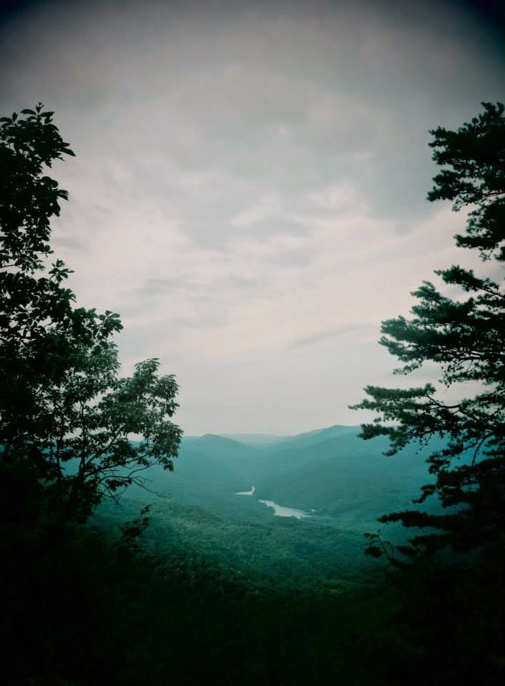
crown jewel of the road is at the end where Pinnacle Overlook offers a spectacular view over Kentucky, Virginia, and Tennessee. I had the overlooks to myself and it was a beautiful sight to behold as the mist was rising off the mountains.
 
I drove back down into the town of Cumberland Gap, TN 
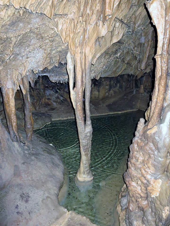
for a quick stop at an old iron furnace before making my way to Gap Cave. The cave is only accessible by tour and was much more intimate and relaxed than Mammoth. Our awesome guide was a history major who was really passionate about the area so I learned a lot and even got to see some cave salamanders! There was much more water in this cave so there were tons of stalactites and stalagmites to behold.
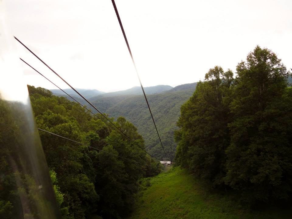
I then wound my way up into West Virginia to grab a campsite at Bluestone State Park. After setting up my tent and eating dinner I backtracked a few miles to Pipestem State Park. The Bluestone National Scenic River cuts through both of these parks and the best access to it is the aerial tram at Pipestem. I hopped in and was whisked 1000 feet downhill in a matter of minutes.

Bluestone Lake
Tram

It is quite the thrill ride and you disembark at a quiet inn and restaurant. I wandered along the river banks, marveling at the stone sculptures along the way. After heading back up in the tram I hiked a couple short trails: one to Long Branch Lake and one to the Bolar Lookout tower which sits at 3,000 feet and offers a view of the area.


There is so much to do at Pipestem and it was such a peaceful park that I really enjoyed my evening there.